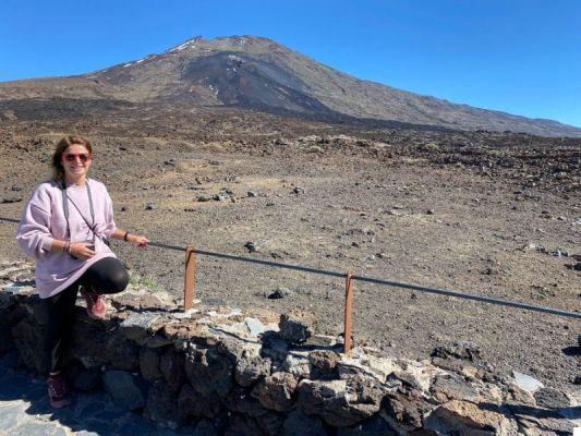
I could not help but dedicate an entire article to his majesty the Teide, the highest volcano in Europe, the highest mountain in Spain, the most beautiful thing of all the Canaries for me. A mountain almost 4000 meters high (is high 3718 mt) which emerged from the sea billions of years ago thanks to an underwater eruption and which we can see in all its beauty, from sea level to the summit. For me this thing is unbelievable! When we are in the presence of very high mountains we usually see them starting from a certain altitude; in the case of Teide, on the other hand, in less than 1 hour you can go from the beach to the snow on the summit. Maybe then I'm sick of volcanoes, but the Teide (and the landscapes around) is really something that has left me speechless. If I had to say what is the thing to see in the Canary Islands being able to choose only one, I would say the Teide (and the whole National Park) without a shadow of a doubt! The peak is visible from practically all parts of Tenerife but also from neighboring islands (La Gomera, La Palma, El Hierro and Gran Canaria); even when the island is cloaked in clouds, the peak is almost always uncovered and visible. For the ancient peoples of the island (the guanacos) the Teide was the abode of fire and its peak was for centuries a fundamental reference point for sailors.
The excursion to Mount Teide and the National Park of the same name is absolutely not to be missed! As you will see in the following paragraphs, the climb must be planned well in advance, but it will be absolutely worth it.
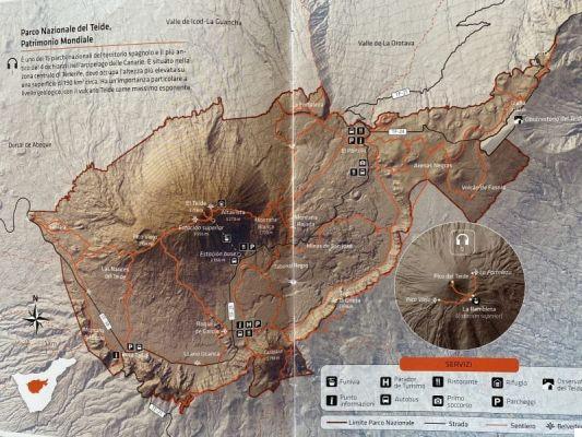
The Teide National Park
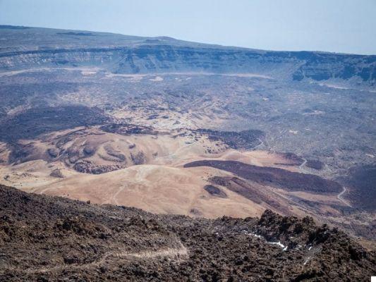
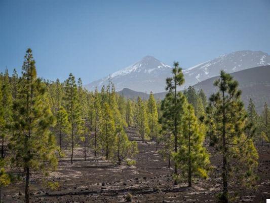
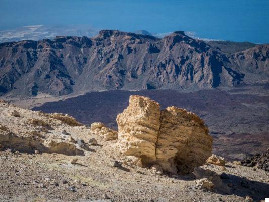
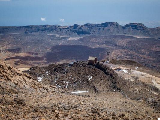
The volcano is part of the great Teide National Park, the largest natural park in the Canary Islands with its 190 square kilometers. The park is circumscribed within the large one Caldera de Las Cañadas, where there are the erupting magmas of several volcanoes, such as the Vulcano Montaña Blanca or Rajada, both younger than Teide. A sort of natural amphitheater formed around these lava flows, consisting of the remains of the volcanoes of the past that collapsed at different times in the geological history of Tenerife. The glimpse of the Caldera de Las Cañadas that you can see from the summit of Teide is truly impressive, an incredibly fascinating apocalyptic landscape, made up of rock formations with surreal shapes, caves and rugged peaks. Teide National Park is spectacular at any time of the year: in summer it is easier to reach the summit, because the weather conditions are better and normally there is no snow, but it is in spring that the Park gives its best, when the summit is still covered with snow and the slopes are covered with flowers. In winter you may not be able to reach the summit (if there is too much snow, the access roads to the park are also closed) and it can get very cold.
How to get to Teide
Getting to Teide by car
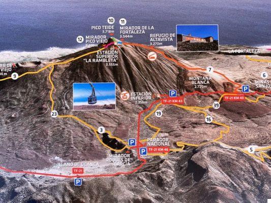
The most convenient way to reach the Teide National Park is by car, which allows you maximum freedom of movement and stops to walk or take photos. To get to the park there are 4 roads, which start from different points on the island. If you come from Tenerife North there are street of La Esperanza, which runs through the dense forest of Pinar de La Esperanza and passes close toTeide Observatory, and the street of La Orotava, which passes from El Portillo Visitor Center, with a small museum on the geological history of the park. Coming instead from Tenerife South there are the Guia de Isora road, which crosses the various Collate of the Pico Viejo (the most recent ones), and the strada di Vilaflor, all of tight curves, which passes through a pine forest and the Cañada Blanca Visitor Center. Among the latter 2, I recommend the first one more, it is more scenic and will allow you to stop in some miradors with superlative views (Samara, Boca de Tauce, etc.).
Getting to Teide by bus (from Costa Adeje or Puerto de la Cruz)
You can also reach the Teide National Park by bus, from Puerto de la Cruz (to the north) or from Costa Adeje / Playa de las Américas.
- Bus 348 from Puerto de la Cruz: departs daily at 9:15 am and stops in La Orotava, Montaña Blanca and at the base of the cable car. It takes about an hour and a half. The return is then at 16:05 from the cable car station and retraces the same road in the opposite direction.
- Bus 342 from Costa Adeje: departs daily from Costa Adeje / Playa de las Américas and reaches Las Cañadas del Teide in two and a quarter hours. Along the way it stops in Los Cristianos and the Teide Cable Car, from where it leaves at 15pm, and in Montaña Blanca.
Explore the Teide with a tour
If you don't have a car and are not comfortable with buses, don't worry, you can explore the National Park and climb to the top of the volcano by participating in a tour. In this case they will pick you up directly at your hotel or at a meeting point. Here are some tours available:
- Teide excursion + cable car (starting from Tenerife South)
- Teide excursion + cable car (starting from Tenerife North)
- Hike to Teide da Tenerife Sud
- Teide excursion from North Tenerife
- Hike to Teide, Garachico, Los Gigantes and Masca starting from Tenerife South
- Excursion to the Teide Park and Porto de la Cruz
- Hike to Teide, Icod de los Vinos and Garachico starting from Tenerife Sud
- Evening trekking to the Teide Park
- Evening excursion to Teide
What to see in the Teide National Park
Inside the park you can limit yourself to reaching the various panoramic points or even go trekking. There are many paths, of all lengths and difficulties. They are all well marked and the risk of getting lost is practically non-existent.
- Samara: in this area there are the most recent flows (of 1798 and 1909) and you can see the black lava in a magnificent contrast with the bright green of the pine forest. From here 2-3 fairly easy and scenic treks start.
- Las Narices del Teide: these openings along the Teide slope opened during the eruption of 1798 and look like large nostrils.
- LLano Ucanca viewpoint: this is one of the miradors with the most beautiful view, you will have the Teide in front of you in all its splendor.
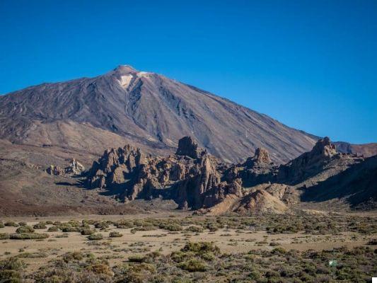
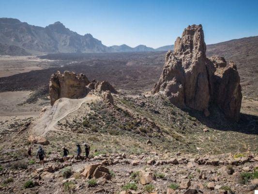
- Roques de Garcia: very particular solidified lava pinnacles to which they have given very evocative names such as "The Cathedral" or the "Finger of God". From here you can take the best-known photo of Teide, the one with the Finger of God and the volcano in the background. Also nice is the 2h trek that circumnavigates these formations.
- Montana Guajara: the highest mountain after the Teide (2718 m), on the "edge" of Las Cañadas. The circular trek to reach it is quite long and demanding (calculate at least 5h between the round trip), but beautiful (it starts from the Parador Cañadas del Teide).
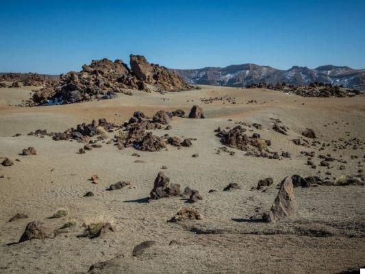
- Tabonal Black: a sea of lava formed by obsidian rocks and other black rocks.
- Mines of San Josè: in this area you will really feel like you are on Mars! Rocks and rock formations of various colors (green, red and yellow), forming a landscape that is incredible.
- Teide Observatory: here is the largest solar observatory in the world and other telescopes that make this area one of the best places to see the celestial vault in the northern hemisphere. It is the twin of the La Palma Observatory and it is possible to visit it (find all the info on the website).
How to get on Mount Teide (3555 m - La Rambleta)
Except in really bad weather conditions (ie snow blocking the access roads), the Teide National Park is practically always open and you can reach it freely. The same thing cannot be said for the ascent to Teide, whether it is only up to 3555 meters or up to the summit at 3718 meters. The weather conditions (especially the wind) at these altitudes change very suddenly and you may find some paths and / or the cable car closed. Before getting into the car, the same morning, always check the weather and the opening conditions of the paths and the cable car from the official website.
Climb Mount Teide on foot
If you are in good physical shape and are fit, you can think of climbing Teide on foot, starting from the road and reaching the summit. There Salita inizia to Montaña Blanca, at 2.320 mt, exactly at this point. If you do not find a place for your car here (there are few places), you will necessarily have to park either at the cable car park or in the few parking lots of the nearby miradors and then reach the starting point on foot. The climb is tough (they are 1500 meters in altitude to the summit!) and on average it takes about 5 hours (only ascent). Also calculate that at these altitudes oxygen is rarefied and it is even harder than normal. The trail passes through the Altavista Refuge (3.260 m) so you can think (and many do) to start the climb before sunset, stop to sleep at the refuge, and then go up to the summit of Teide at dawn (in this case you will not even need to request permission (see below). The Refuge must be booked in advance and you will also have to check that it is open (at the moment it is closed for compliance with anti-Covid regulations). Once up, you can decide whether to go down on foot or by cable car (21 euros).
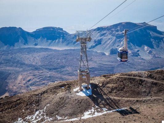
Go up to Mount Teide by cable car
The most convenient alternative is to go up with the cable car, which climbs 1199 meters in just 8 '(prohibitive for heart patients and for those suffering from vertigo), and goes from the Base Station (2356 meters) up to La Rambleta (3555 mt). In this period, with the island empty than usual, there is no need to book in advance, but normally you do. In pre-covid conditions it had to be booked at least 1 week before or more. You can book / buy tickets from Official site (21 euros one way or descent, 37 euros return). If the weather conditions are bad, the cable car will be closed without warning, but you will have the option to move your ticket or request a refund. Precisely for this reason, if you intend to stay a few days in Tenerife, book the Teide for the first few days, so, in the case of cancellations, you will have other days to try to climb.
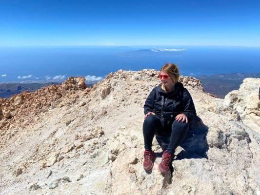
How to apply for a permit to climb the Teide peak (3718 m)
The arrival of the cable car is located at 3555 meters, but the summit of Teide is 160 meters higher. To reach the top and see the crater however, you will need a permit why theaccess is limited to 200 people per day (remember that we are still talking about an active volcano!). This permit must be requested well in advance (pre-covid also meant 2 months before, now a few days before are enough) through the site of the Spanish Natural Parks. You will have the choice between 4 time slots: 9-11, 11-13, 13-15, 15-17. Outside these hours, so before 9am and after 17pm, admission is free (but it does not arrive and find a place through this site, you can consider buying a combined ticket cable car + permit permit for the summit from the Civitatis site (however, there is not every day). Furthermore, only on some particular days is it possible go up with the cable car at sunset, and from there to the summit, to enjoy the show (you can buy the ticket through this site).
What to do on Teide: the paths to the top
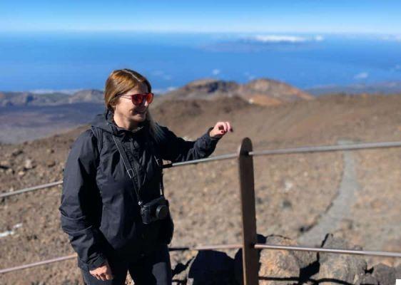
If you want to climb to the top but don't get the permit, don't despair because the best view is actually lower down. At least for me, it's the one you can enjoy from the Pico Viejo viewpoint. From the arrival of the cable car to La Rambleta, in fact, you can freely follow 2 paths to see as many panoramic points (the paths N. 11-12); they are practically flat, or a little more, but with the rarefaction of oxygen you will still have breathlessness and some dizziness (but it depends from person to person). The path N.10 is instead the one with a limited entry that reaches the summit.
Path N.12 Belvedere Pico Viejo
This path winds to the left of the cable car and offers, for me, the most beautiful views. You pass by rocks of various colors (yellow, red and white), before arriving at the Mirador from which you will have a crazy view of the collapsed crater of the Old Peak vulcano (one of the largest in the Canary Islands) and on the islands of El Hierro, La Gomera and La Palma. The Pico Viejo is located at the apex of the Abeque ridge, where the most recent volcanoes of Tenerife are concentrated (including the Chinyero, which erupted in 1909).
Path N.11 La Fortaleza Belvedere
The path of La Fortaleza instead winds to the right of the cable car to reach the mirador of the same name. From here you can see the whole northern area of Tenerife, with the massif of anaga and La Orotava valley, and Gran Canaria in the background. If you have permission to climb to the top, you can avoid coming here as you will have more or less the same view.
Path N.10 Telesforo Bravo (summit of Teide)
This path climbs towards the summit of Teide, the apical cone formed with the last eruption of the volcano. To reach it, you go up along the beginning of what was once a lava river, a kind of tunnel with high walls. The path is short (they are 160 meters of altitude difference), but very tiring, both because it is steep and because of the lack of oxygen. Walking slowly you will reach the summit in about 20 minutes. As you will see, in the cone, there are still some sulfataras that give off steam and heat, so you have to be careful. From here, of course, the view sweeps 360 ° over the whole island and it is a spectacle that truly leaves you speechless. You will have arrived at the highest peak in Spain, rest and enjoy this wonder!

How to dress to climb Mount Teide
When you leave for Tenerife you could leave with swimsuits, slippers, shorts and little more, but you will need more if you intend to climb Mount Teide! Whether you go there in summer or winter, at 3718 meters it's cold and you'll have to cover yourself. In winter, temperatures at high altitudes can drop abundantly below zero, while in summer we may be talking about temperatures that fluctuate around 5-10 °. And if you catch a windy day, you risk suffering the cold even more!
If you want to climb Mount Teide, whether on foot or by cable car, I recommend that you put in your suitcase at least a thermal shirt, a heavy sweatshirt, a 100g down jacket, a windproof jacket, gloves, a scarf and (in winter) a tights. put under your pants.
You might also be interested in these other articles I wrote about the Canary Islands:
- What to see in Tenerife South: 10 places not to be missed
- What to see in Tenerife North: 10 places not to be missed
- Where to stay in Tenerife: the best areas
- Canary Islands: which ones to choose
- The 15 most beautiful beaches in Tenerife
- La Gomera (Canary Islands): what to see
- What to see in La Palma, the 'isla bonita' of the Canaries
- What to see in Lanzarote: all the places not to be missed
- El Hierro: what to see and what to do
- Fuerteventura: what to see and where to go
- How to organize a trip to Lanzarote
- The most beautiful treks in Lanzarote (Canary Islands)
- La Palma (Canary Islands): the most beautiful treks
- Lanzarote: the most beautiful beaches and natural pools
- Smartworking from the Canary Islands: info and useful tips for digital nomads